Laura Bourgeau-Chavez of the Michigan Tech Research Institute shares information about a mapping study designed to develop standardized methods and recommendations for evaluating the effectiveness of herbicide treatments on Phragmites and the post-treatment restoration response of natural vegetation and faunal biodiversity.
What type of project is this?
- Education/outreach
- Planning
- Research
What is the geographic scope of the project?
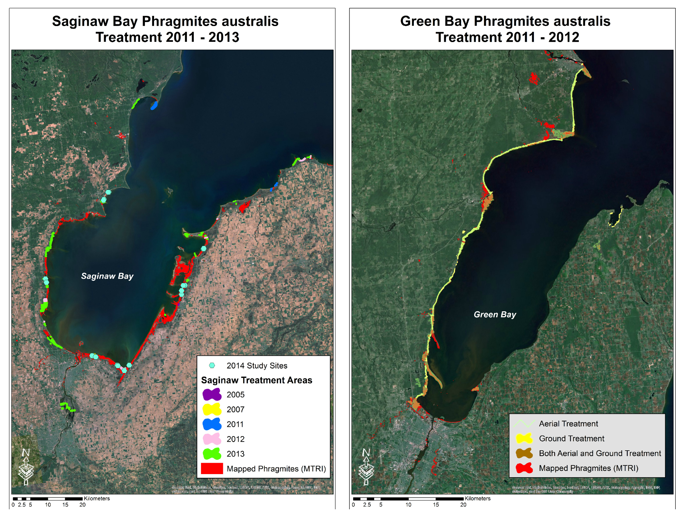
The study is focused on two bays of similar geomorphic type; one in Wisconsin on Lake Michigan and the other in Michigan on Lake Huron. The study encompasses the coastline of Wisconsin’s Green Bay ranging from the city of Green Bay, north to Pensaukee. The second second study area extends across Michigan’s Saginaw Bay, with focus on the coastal region between Au Gres in the northwest part of the bay to Bay Port in the southeast.
 Why is Phragmites an issue in your area?
Invasive Phragmites australis has become an acute detriment to coastal Great Lakes wetlands. Due to its fast-growing nature, Phragmites has the ability to outcompete native wetland plants and dominate the ecosystem. Once established, invasive Phragmites is capable of forming dense, tall (up to 5 meter / 16 feet) monocultures that are difficult to control without continuous and long-term management. In the Great Lakes region, Phragmites invasion has had many negative impacts on the ecosystem including reduction of habitat quality and biological diversity (flora and fauna), modifications in hydrological regimes, drying of wetland soils, increased air temperature within a wetland and reduction of shoreline views, which may negatively affect property values. Resource managers report spending over $80 million on herbicide treatment of the invasive plant over the past several years. Most treatment is applied without assessment of the effects on habitat, typically only the presence/absence of the invader is monitored for 1 year post-treatment.
What is your organization’s approach to invasive Phragmites management?
The project team is using high and moderate resolution remote sensing and field based studies to detect and map the location of Phragmites over large expanses of land and the effects of treatment on vegetation recovery. Utilizing synthetic aperture radar (SAR 20 m resolution data) data, MTRI developed a US Great Lakes basin-wide map of monocultures of the invasive Phragmites austrailis from PALSAR satellite imagery circa 2008-2010 (dataset available on the USGS CIDA website http://cida.usgs.gov/glri/phragmites/). Follow-on remote sensing and field studies are suitable to expand on this mapping effort, and develop a baseline method for assessing the effectiveness of treatment. The current project is designed to fill a gap in knowledge of assessment of chemically treated invasives and the recovery of the native ecosystem.
Who are your partners in this effort?
We are partnering with Applied Ecological Services (AES), an ecological consulting firm located in Brodhead, Wisconsin. AES is collecting field survey data in Green Bay, as well as providing high resolution oblique and nadir looking aerial imagery of both study areas.
We are also partnering with Don Uzarski of Central Michigan University (CMU). His role is in implementing avian, amphibian and vegetation field collection protocol as developed for an ongoing Great Lakes Coastal Wetland Monitoring project and guiding the statistical analysis. CMU collected pre-treatment bird, amphibian and vegetation data as part of their wetland research from past years, allowing us to evaluate the longitudinal changes to habitat and biodiversity pre- and post-treatment.
What are the funding sources?
Funding for the study is provided by a grant from the University of Michigan Water Center – Graham Sustainability Institute. The Water Center has awarded over $4.6 million in large grants to bolster freshwater research and restoration and protection efforts throughout the Great Lakes region and beyond. The grants program is an important part of the Water Center’s efforts to enhance restoration and protection activities by engaging exceptional multi-sector teams in advancing evaluation and assessment of restoration projects.
This funding builds off previous research funding from the Great Lakes Restoration Initiative and Environmental Protection Agency under cooperative agreements with the United States Geological Survey Great Lakes Research Center and the US Fish and Wildlife Service, where Phragmites extent maps were created by MTRI using a fusion of optical and SAR data along with an extensive field campaign.
What are the goals and objectives for the project?
The project goal is to develop standardized methods and recommendations for evaluating the effectiveness of herbicide treatments on Phragmites and the post-treatment restoration response of natural vegetation and faunal biodiversity. The research is being conducted in two study areas: Green Bay and Saginaw Bay. Treatment effectiveness is being assessed in a nested scaling design, from field surveys to high resolution aerial imagery to moderate resolution satellite imagery. A comparison will be made of pre-treatment Phragmites distribution maps of the U.S. coastal Great Lakes (circa 2008-2010) with post-treatment imagery and field surveys collected by the project team. Aerial imagery will be interpreted and classified for Phragmites identification, effectiveness of herbicide treatment, and restored wetland function. Standardized biodiversity sampling protocols currently used by the Great Lakes Instrumentation Collaboratory are being used for continuity.
This information will be invaluable for assessment of the current typical management approaches (herbicide, burning or cutting) and the development of future management approaches. It will also provide novel analysis of post-treatment recovery of wetland ecosystems in the coastal Great Lakes by placing wetland response into the context of the greater regional landscape.
What type of land does your project target?
Our project targets the coastal wetland areas in both Green and Saginaw Bay, but the conclusions found there can be used throughout the Great Lakes Basin in regard to Phragmites herbicide treatment, evaluation and monitoring.
Do you monitor the areas that you manage? If so, what does that entail?
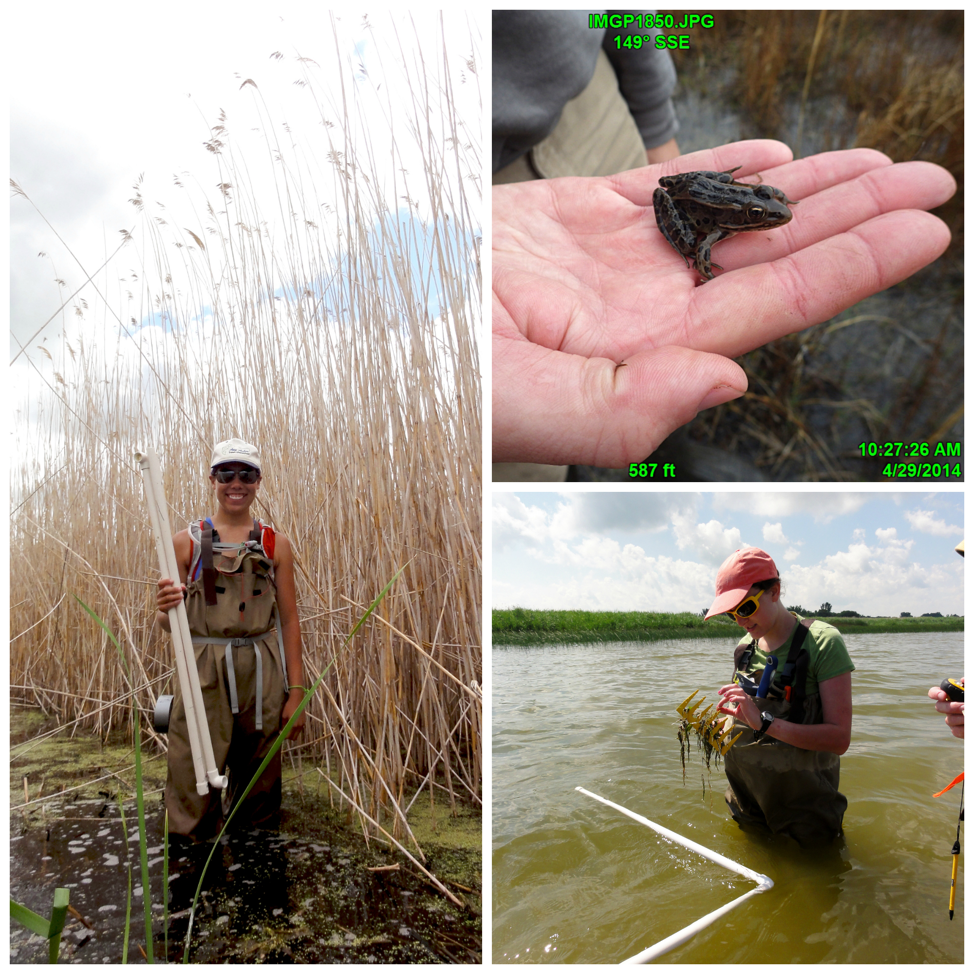
Field surveys of birds, amphibians and vegetation are being conducted each year of the project. Field sites have been established for the amphibian and avian counts, as well as the vegetation transects, in both treated and non-treated Phragmites. We are currently compiling the field data from our initial year and hope to have preliminary results in the fall of 2014. These data will be compared to pre-treatment sample data from the CMU team. The same protocol is used by this project as was used by CMU to maintain continuity. A before after control impact (BACI) statistical analysis will be conducted and allow us to assess the effectiveness of treatment in the two Bays.
Aerial imagery is being collected in June and September 2014 (post-herbicide treatment). This dataset will allow for expansion of the field-based transect studies across the bays and also provide training data for moderate scale monitoring of the project areas via low-cost remote sensing systems, such as Landsat 8. Landsat 8 is an electro-optical satellite that is operated by the USGS that posts the imagery free of charge making this sensor very appealing for continued monitoring. Landsat 8 has a repeat orbit of 16 days; this enables land managers to monitor treated areas roughly twice a month at little to no cost. One issue with Landsat is that as an Electro-Optical sensor data collection is constrained by cloud cover and weather – if it is cloudy over the treated area then Landsat will not collect any information on ground conditions. The project team is also using new satellite radar data (PALSAR-2) which provides information on stand structure and biomass and it is collected irrespective of cloud cover or daylight because it has its own energy source and a wavelength of about 24 cm which penetrates clouds. The use of these low-cost sensors will enable future monitoring of both treatment efficacy and species re-establishment post-treatment.
 What is the status of the program and are you seeing results?
The program is still in the data collection stages. All of the field data collections (birds, amphibians, vegetation) for year 1 (2014) for Green and Saginaw Bays will be complete by end of August 2014. The data are being entered and quality controlled; then indicators of biological integrity (IBI) will be calculated. Once this is done we will be able to evaluate the control versus treatment areas and use the before treatment data from CMU to evaluate changes pre- and post-treatment.
Aerial imagery surveys (obliques and nadir-looking) of both Bays were collected in June 2014 by AES and a subsequent fall collection will be conducted in September 2014. These two date datasets of 6 inch resolution imagery will be used to map vegetation and the field surveys will be expanded across the landscape to observe the geospatial effects of treatment on the vegetation.
Can you share information about challenges and lessons learned (both about what worked and what did not work)?
One of the biggest challenges of this project was finding the information about treated areas of Phragmites along Saginaw Bay. Green Bay underwent a large blanket aerial spraying operation in 2011, conducted by the Wisconsin DNR. The DNR documented the treated areas well with flight lines of the plane used for spraying, so the treated areas were known at the start of our project. For Saginaw Bay treated sites were largely unknown. There were many different organizations conducting treatment and we contacted each one to obtain GPS information on treatment areas, type of treatment, timing, etc. Most of our information originated with the Department of Environmental Quality (DEQ) database of permits for herbicide treatment applications. The process of calling each of the land managers, gathering maps and other information and compiling a GIS database was challenging, but it also acquainted us with a group of end users who would likely be interested in the outputs of the project. See figures showing study areas and areas of treatment by year versus extent of Phragmites stands.
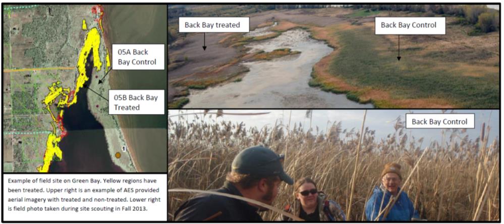
Another challenge was in pairing up treatment and control sites in each bay. For Saginaw the difficulty was in finding large enough herbicide treatment areas to pair up with control sites. As of spring 2014, most of Saginaw Bay is untreated. For Green Bay with the organized blanket herbicide by the WDNR, the difficulty was in finding control sites of Phragmites untreated stands that were large enough to pair with treated sites. Sites of similar hydrogeomorphic type are being paired (see figure showing an example of a treated and control site pairing on Green Bay).
 Please provide any other information here.
This project will fill in critical gaps in knowledge by providing peer reviewed scientific manuscripts on effectiveness of herbicide treatments on spread of invasive Phragmites, and recovery of wetland ecosystems in the context of biodiversity. It also provides an analysis in context of landscape scale rather than just point source field information, but also allowing us to determine the effects of surrounding land use.
At the end of the project resource managers and other end users will have either confirmation of current treatment methods, or recommendations for further, more effective adaptive management strategies.
For more information, please contact:
Laura Bourgeau-Chavez, Ph.D.
Michigan Tech Research Institute
3600 Green Ct., Ste 100
Ann Arbor, MI 48105
United States
(734)913-6873